Bright morning sun radiating through a cloud in an otherwise blue sky over a Puget Sound seen from the deck of a ferry about to land at Vashon island.

Five Scenic Transit Rides You Can Take in the Seattle Area

Most of my readers and my mailing list are in the greater Seattle area and might have heard the claims about how popular “scenic driving” is along Lake Washington Boulevard (LWB), especially if you are familiar with efforts to provide more space for people walking and rolling along this jewel of the city’s park system. TL;DR: people opposed to re-allocating some space along LWB from cars to use for non-motorized transportation and leisure say that so-called scenic driving is much more popular than activities like cycling — though Seattle Parks’ own data from its most recent survey shows very much otherwise.

Whether or not scenic driving is a thing, or in high demand, the presence across the nation of many so-called scenic byways notwithstanding, I don’t think it’s pedantic of me to note that driving is best an activity one devotes one’s full attention to, given the possible consequences of inattention. Anyway, who wants to split their attention from our region when we’re out to enjoy its natural beauty? Luckily, our transit system doesn’t force people to choose.

Here are a bunch of transit routes in the city of Seattle and the surrounding region that offer high scenic value, so folks can focus their full attention on mama nature, the way she intended all of us to.

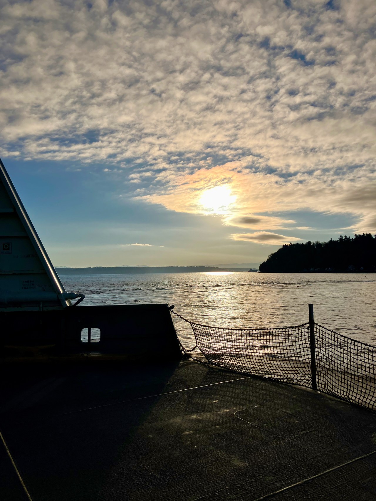
Pick a Ferry. Any Ferry.

Short on time? Hop on the King County Water Taxi from downtown Seattle over to Alki and back. Need a personal day or just have a weekend with a lot of free time? Spend a big chunk of it on a leisurely sail on the WSDOT ferry to Bremerton, and combine with a Kitsap Transit foot ferry to Port Orchard and back, and then return. Water, mountains, and maybe some water mammals all await you.

Take Sounder Along the Sound

Hop on the Sounder‘s north route (AKA the N Line) and enjoy some sound-side viewing. The train runs right along the coastline — and I DO mean right along for much of the journey between Seattle and Everett, and you’re almost certain to get up-close views of bald eagles, herons, seals, and even sea otters. Pro-tip: take the early run and return to Seattle on the train. Hall of fame tip: Grab a ticket for an Amtrak Cascades train to Bellingham and back for even more sound-side scenery.

Discover Lake Dell Avenue

Lake Washington Boulevard is indeed a wonderful local destination. While there is an unfortunate lack of bus service along the boulevard — at least right now — when you’re in need of a scenic ride close to home and a bicycle or walk isn’t your thing, hop on King County Metro’s route 27 for a short but sweet jaunt along the lake and a fun, twisty-turny trip up or down Lake Dell Avenue. Take it round trip to downtown and back — the westbound Yesler stretch of the route presents the city and the sound in some of their best light.

Take a Strait Shot

Clallam Transit’s Strait Shot will let you savor the grandeur of the Olympic Peninsula, including breath-taking, soul-refreshing crossings of Agate Pass and the Hood Canal and the soothing expanse of Discovery Bay. Bonus: you get to take the Bainbridge ferry to catch the Strait Shot!

Camano Island

Take Amtrak Cascades to Stanwood, then transfer to take Island Transit (fare free!) Camano route 1 or 2 for marine vistas available as far as the eye can see.

As always, this list is far from comprehensive. Have you got a favorite scenic transit route in the Seattle area? Comment below or use the contact form to tell me about it and I’ll update this post.

Image: View from the deck of the Fauntleroy to Vashon ferry on a late fall morning. Copyright 2023 Transit Trekker/Downshift Outdoors.

Action Alert — Pedestrian Access on the Bridge of the Gods

While house-sitting this week in Hood River, OR, I took the bus to Cascade Locks to check out transit hiking conditions at the southernmost Washington trailhead of the Pacific Crest Trail (PCT). My assessment? Mixed. And in some cases — decidedly not great. And a lot of that is because you have to cross the Bridge of the Gods over the Columbia River to continue on the PCT, whether you are traveling northbound or southbound.

I did some preliminary digging to see if I could understand why authorities have not done the most minimal separation — simple concrete curbs and a few flex posts? — to afford pedestrians real space while crossing the bridge. I didn’t find the fulll answer to that question, but did find that there is local support for a pedestrian bridge, some preliminary funding and studies were secured, but due to some byzantine federal rules about toll bridges (vehicle drivers pay tolls) the pedestrian bridge addition is on indefinite hold. As I said in my Twitter thread, I don’t know numbers for locals who cross the bridge on foot, but I do know that in 2023 people should not have to walk in a lane of traffic to cross a major river.

Just a couple weeks ago, the Pacific Crest Trail Association published a Call to Action to urge legislators in both Oregon and Washington to fund the bridge. It’s a short read and easy to sign on. Please sign and share.

wheat-like grasses in dark copper shades

Perico Bayou

An illustrated map of Perico Preserve, done in a sort of bright, childlike style.
This bright, illustrated map welcomes visitors to Perico Preserve

In January I visited Florida for family matters and managed to slip away from the confines of the subdivision for a couple of local transit hikes.

Manatee County Area Transit (MCAT) stops at three preserves on its way to Anna Maria Island — Neal, Perico, and Robinson. I aimed for Robinson. (Note the pdf does not say but the main MCAT site notes service is Monday-Saturday.)

On my first trip I got off the bus at the Manatee Ave W at Perico Way stop, which looked to be a short walk backtracking east to the path leading to the preserve entrance.

En route to Robinson I discovered Perico Preserve, which shares an entry point on Manatee Ave W with Robinson. The Perico entrance at first gives an unremarkable impression, with a trail running alongside both the bayou but also the regrettable SFH development across the bayou. I didn’t expect much, and meant to take only a short detour onto what I assumed was just a single, short loop trail.

I was surprised and mesmerized pretty quickly, and ended up spending my midday at Perico. The first time it occurred to me to look up into tree tops, I saw an osprey chowing down on a fish in on a low tree branch not too far from me.

Perico can’t have more three miles of trails. Yet I easily found myself wandering for a couple of hours through this tranquil preserve’s varied ecosystems, from desert-like to more typical (to me) Florida tropical forest (and the SFH development quickly recedes from view).

Desert feels somewhere in Perico Preserve.

Bicycles are allowed in many parts of Perico (and Robinson), and most areas where they are not are gated off with clear signage, and, thankfully and thoughtfully, with bike racks adjacent the gates. Generally I found both people walking and rolling to be communicative and considerate of sharing the space, with the vast majority of cyclists riding slowly and giving others lots of space when passing. (I’m uncertain about Neal, since I did not visit.) Kid-friendly, for sure, though Robinson seemed more popular for little kids.

View from a bird blind in Perico Preserve

This is Florida, so these preserve trails are quite flat (certainly by my Pacific Northwest standards). Some surfaces are paved — Robinson in particular has some long paved pathways. Those remaining unpaved are mostly hard-packed enough that I think any mobility aid that can handle intermittent gravel and small debris could work here. The portapotty on the other side of the Manatee Ave W (see below) is large-ish but I can’t confirm if it would work well for a wheelchair user.

I found a portapotty at a Perico trailhead (a parking lot west of the bus stop at Perico Way) that was literally full of shit, up to the top of the toilet seat. You can walk under Manatee Ave W at the bridge over the bayou via a bike/walk path to another parking lot with portapotty that on my visit was in much better condition. There are also several bathrooms at nearby Robinson Preserve, though they are a bit of a trek.

This path under the arterial is also the path you’ll want to take to cross the arterial to catch the bus back toward Bradenton.

No dogs allowed here; I assume because it’s a small, sensitive area that is still being rehabilitated and to minimize potential threats to wildlife.

Tl;dr — MCAT Route 3 from Downtown Bradenton (and from points east mostly along Manatee Ave) will take you to three fantastic and pretty damn accessible day hikes at three reserves. I recommend a full, long day to fully explore Robinson, arriving early, and at least a half day each at Perico and Neal Preserves (though note I wasn’t able to scout Neal personally). If you remain on the 3, you can enjoy Anna Maria Island, which looks like it could be a pretty sweet car-free destination.

Some other notes: I remain confused as to the difference between the seasonal (always free? 7 days a week?) MCAT beach shuttle and route 3. My Saturday visit to Perico required a transfer in a strip mall parking lot (easy, because traveling both coming and going the transfer bus was waiting and departed immediately after passengers boarded). When I visited Robinson using the same route and bus stop on a weekday, the bus I boarded at the downtown Bradenton transit hub was outfitted as a trolley and traveled to the beach without requiring that parking lot transfer. The route 3 does not operate on Sundays, but the beach shuttle might? I’d clarify with the driver because MCAT doesn’t make it very clear.

MCAT has some things Seattle area transit does not always have, like public restrooms at the downtown transit hub in Bradenton. In late 2022 it started an 18-month fare-free pilot. Buses have onboard electronic signage with audio that in theory announces next stops clearly both visually and with audio. However, some fundamental communications failures marred my initial good impressions as well as costing me quite a bit of time, including zero posted info about schedule reductions related to the operator shortage. Signal timing at downtown crosswalks required long waits to cross the street, and the two main E-W one-way streets are effectively highways. Outside the immediate downtown. area near the transit center, signalized crossings thin out quickly, requiring long walks. One downtown highlight: Kefi Streetside Cafe, just around the corner from the downtown Bradenton transit center. It has ample outdoor seating, pipes through cool and not-too-loud music, and is well-buffered from the adjacent parking lot.

More on Robinson Preserve in another post; there are some great things going on there for car-free recreators.